Bathydrone: Path Planning for Underwater Sensing considering Tethered System Dynamics
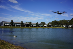
We aim to create and test a system capable of measuring underwater areas and features in areas highly prone to change, including but not limited to coastal areas, tidal zones, ports, canals or water bodies that have an immediate impact on the hydrologic health of an ecosystem. The “bathydrone” is an unpowered boat equipped with a down-scan and side-scan sonar transducer mounted on the hull, towed by a medium-sized UAV. Ongoing and future research topics include:
- Efficient Underwater 3D Point Cloud Mapping using Sonar
- “Dual-control”: developing a path planning and control algorithm for the drone such that the sonar unit can scan the targeted area. Considering bridge inspection applications, collision avoidance will also be considered in this algorithm.
- Underwater camera and sonar fusion: bathydrone system can equip underwater camera inside. By utilizing underwater camera and sonar data obtained from the same pose, sensor fusion algorithm will be developed to improve accuracy in underwater environment monitoring.
Information-driven Path Planning for Underwater Target Recognition
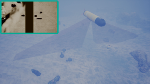
Unlike camera images, SONAR images are very noisy and vary greatly depending on the viewing angle of an object, because the highlight and shadow pattern in the obtained images is changed based on the angle of the reflected surface. These properties of SONAR imagery require the robots to obtain observations from multiple views to achieve satisfactory classification performance, leading to a time-consuming mission. To tackle this problem, an information-driven sensor path-planning algorithm is proposed so that the underwater robot can minimize the operation time while achieving a satisfactory classification performance by only obtaining informative observation. This work is based on previous work on single target classification that utilizes a pre-trained convolutional neural network and a newly-trained support vector machine. This single target classification approach is then extended to estimate the confidence level on target classification depending on the viewing angles. Using this expected confidence level, an information-driven sensor path-planning algorithm is developed to minimize the operation time while achieving a satisfactory classification performance by only obtaining informative observations.

MagNav: Information-driven Navigation under Localization Uncertainty
Although many outdoor autonomous robotics systems rely on GPS, there are some situations or applications where GPS signal is unavailable, e.g., navigation in an underwater environment, receiving a degraded or jammed GPS signal. One solution to this GPS-denied navigation is magnetic anomaly-based navigation, which allows robots to localize based on a series of magnetometer readings and a pre-known magnetic field map. In this project, we focus on developing information-driven active localization methods that plan a path for reducing localization uncertainty.